COASTAL SEA LEVEL NETWORK
NIEP has developed a coastal network for marine seismicity, by installing three new seismic stations, in the coastal area of the Black Sea, at different sites: Constanta (TSCT), Mangalia (TSMN) and Sulina (TSSL). Each station provides information about: seismic data, GNSS data, water level, precipitation rate, wind speed, wind direction, air temperature, air pressure, relative humidity, water pressure, water temperature.
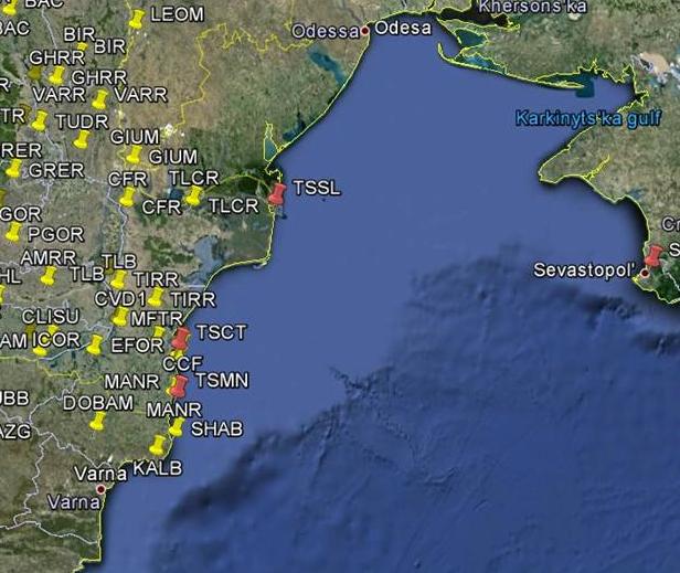 Fig.1 Coastal network of seismic monitoring for the Romanian shore.
The network is composed of 3 systems, each system consists of the following four parts: a marine part (radar tide gauge sensor, pressure sensor, tide gauge datalogger, GPS, weather station, power supply unit), a seismometer system (3 Kinemetrics Systems), a computer system and a modular cabin. The architecture of each Costal Seismic Station is sketched below. Besides the three seismic stations, a coastal gauge station (CGS), for sea level monitoring, was installed at water depth between 12 and 20 m.
| STATION LOCATION ONSHORE | Constanta | Sulina | Mangalia |
|---|---|---|---|
| STATION CODE | Site01 / TSCT | Site02 / TSSL | Site03 / TSMN |
| LATITUDE | 28,65 | 45,16 | 43,80 |
| LONGITUDE | 44,16 | 29,72 | 28,59 |
| MARINE COMPONENT 1 | radar tide gauge sensor: OTT model RLS | radar tide gauge sensor: OTT model RLS | radar tide gauge sensor: OTT model RLS |
| MARINE COMPONENT 2 | pressure sensor: In-situ model Level TROLL 500 with anti-folding shield | pressure sensor: In-situ model Level TROLL 500 with anti-folding shield | pressure sensor: In-situ model Level TROLL 500 with anti-folding shield |
| MARINE COMPONENT 3 | tide gauge datalogger: OTT model DuoSens | tide gauge datalogger : OTT model DuoSens | tide gauge datalogger : OTT model DuoSens |
| MARINE COMPONENT 4 | GPS: MODEL SEPTENTRIO ASTERX2E HOC GPS/SBAS Ll+L2 | GPS MODEL SEPTENTRIO ASTERX2E HOC GPS/SBAS Ll+L2 | GPS MODEL SEPTENTRIO ASTERX2E HOC GPS/SBAS Ll+L2 |
| MARINE COMPONENT 5 | Weather station: Davis Instruments MODEL Cable Vantage Pro2 | Weather station: Davis Instruments MODEL Cable Vantage Pro2 | Weather station: Davis Instruments MODEL Cable Vantage Pro2 |
| SEISMIC COMPONENT 1 | Q330S data logger | Q330S data logger | Q330S data logger |
| SEISMIC COMPONENT 2 | PBB 200S portable broadband Seismometer | PBB 200S portable broadband Seismometer | PBB 200S portable broadband Seismometer |
| SEISMIC COMPONENT 3 | FBA ES-T episensor | FBA ES-T episensor | FBA ES-T episensor |
Reception and interpretation of real-time sea-level measurements
NIEP is responsible for the sea level measurement network built in Marine Geohazard project. In collaboration
with JRC (Joint Research Centre) has recently installed 3 stations in the western part of Black Sea in the framework of a JRC project for the development of an “Inexpensive Device for Sea Level measurements” (IDSL). Each IDSL station is equipped with microwave sea level sensor. The stations have also a barometric sensor, temperature, humidity sensors, water temperature sensor, wind speedometer and direction sensor. The sea level sampling interval is 15 s, but the transmitted data rate is 1 sample per minute (average of 4 samples). All the Black Sea-IDSL stations are connected to the JRC centre through a GPRS system. The data are received at JRC and are sent in real time to NIEP.
At NIEP was developed the procedures to collect sea level data in real-time from the IDSL stations. Also NIEP exchange sea level measurement data with JRC. IOC and all CTSPs from NEAMTWS area. NIEP receives data from all the Black Sea and the Mediterranean gauges collected at the IOC Sea Level Monitoring Facility. NIEP receives at the National Data Centre sea level data streams from IDSL and other sea level stations in ASCII format. Using locally developed plugins data is converted to mseed format using SeedLink. All the data are stored in NIEP Antelope database where we have state of health information.
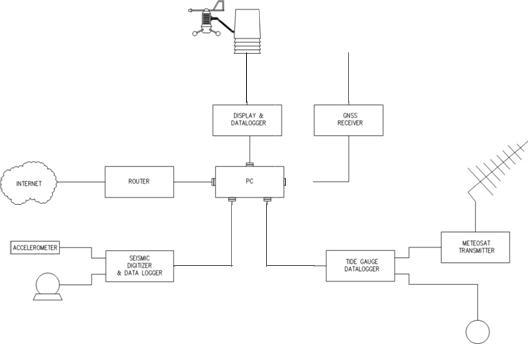 Fig. 2 Coastal Seismic Station Architecture.
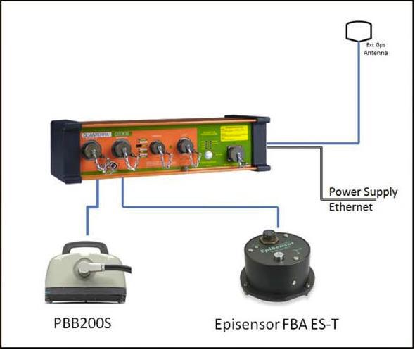 Fig. 3 Block diagram of the seismic equipment.