TSUNAMI FORECASTING SYSTEM
NIEP uses seismic source parameters, as first indicator of tsunami generation, and are used as the basis for the initial tsunami warning decision. The warnings are based on seismic parameters generated by Seismic Earthquake Early Warning and Antelope software. Warning reliability is improved using sea level data from the nearest coastal tide gauge station, which are used to confirm the generation of a tsunami. The system operational at NIEP headquarters uses the JRC Tsunami Assessment Modeling System(TAMS), a tsunami consequence assessment tool based around the simulation of Tsunami wave generation and propagation. The system is developed and implemented by the Joint Research Centre of the European Commission (JRC, http://ec.europa.eu/dgs/jrc/index.cfm). It is currently operational and processing in real time all the events occurring in the world, calculating the expected Tsunami wave height and identifying the locations where high wave heights are expected. The system is deployed as part of the Global Disaster Alert and Coordination System (GDACS, http://www.gdacs.org/). The Tsunami Calculation System employs models and algorithms to predict with a high level of accuracy the correct time of tsunami wave arrival, height of the water and inundation of the coast, given earthquake information and by exploiting static elevation data of the sea bottom and coastal land area. It contains an off-line modeling tool for the pre-calculation and storage in a database of the result of the simulation of tsunamigenic earthquakes of varying magnitudes and location in the deployment zone. This Tsunami Scenario Database provides an instant solution (a few seconds of CPU time) when the occurring earthquake source parameters, provided by external institutions via their bulletins and fast notification systems, are very similar to a pre-calculated one. In this case travel times, wave height and flooding maps, animations and web pages are immediately available to the warning centre, and can be refined as time passes.
For earthquakes differing from those in the database, a real-time calculation is initiated. The Tsunami Online Calculation System is able to estimate the arrival time and height of tsunami waves starting from minimal earthquake parameters (hypocenter and magnitude) without user intervention. The first result, available within 10-20 seconds from the event publication and start of the new calculation, is the travel times to the coast. The initial water displacement is derived by automatically estimating the fault length, height and direction, using the known fault lines, as this is the only information available in the first few minutes following the event publication.
A front-end to the described systems is also provided, the Tsunami Analysis System (TAT). It receives the information on current seismic events from seismic monitoring institutions, as well as water level measurements from the deployed hardware. It displays the measurements and interprets them, in order to compare with calculated data. If enough measured data are available, determines the initial tsunami condition most compatible with the ongoing situation, and uses it for the simulation.
The Tsunami Analysis Tool allows an analysis of tsunami events in real time, when they are occurring, in order to give decision makers in a crisis room the ability to decide if an event can lead or not to a tsunami and, in case a tsunami does occur, to properly evaluate its possible consequences. The tool allows to access all the available scenario tsunami calculations and makes it possible to compare the available sea level measurements and additionally from web resources of other institutions to those being calculated in the simulation and to the scenario ones (Figure 1).
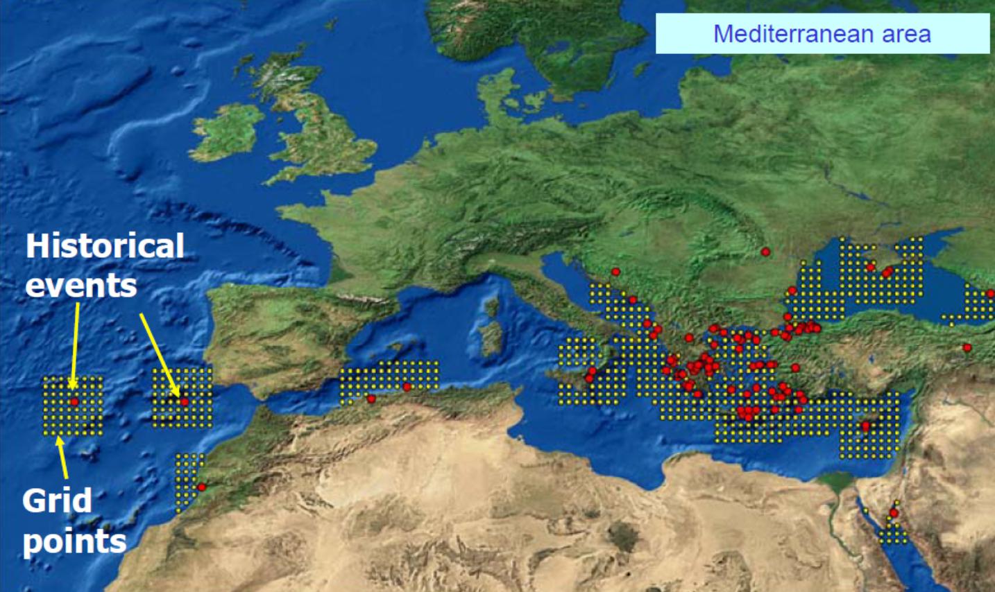 FFigure 1.Grid of pre-computed scenarios around historical tsunamigenic earthquakes in Europe, currently available to the Tsunami Assessment Modeling Tool
NIEP has developed a coastal network for marine seismicity, in the Black Sea, at different sites, in Constanta (TSCT), Mangalia (TSMN) and Sulina (TSSL) cities. Each station provides seismic data, GNSS data, water level, precipitation rate, wind speed, wind direction, air temperature, air pressure, relative humidity, water pressure, water temperature. Also NIEP receives data from 5 Buoys system installed in the framework of MarineGeohazard project (http://www.geohazard-blacksea.eu/) (Figure 2).
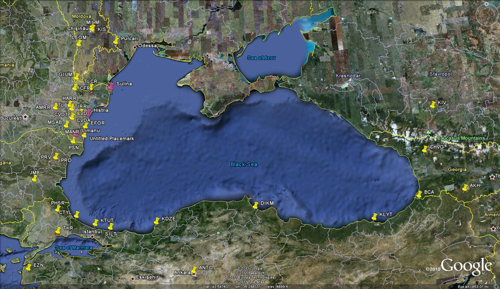 Figure 2. Data exchange with Black Sea countries involves the acquisition of real-time data for 17 stations from Bulgaria, Turkey and Georgia
The Tsunami Buoy (STB) System installed in the framework of the above project is able to record wind speed, wind direction, air temperature, air pressure, relative humidity, oxygen concentration, water temperature, water conductivity, turbidity, water pressure, chlorophyll, air saturation, compass, water current amplitude, water current direction, latitude and longitude. The recorded data is sent through GEM (Figure 3), an acquisition system developed during the project that allows storage and alert at NIEP (Figure 4).
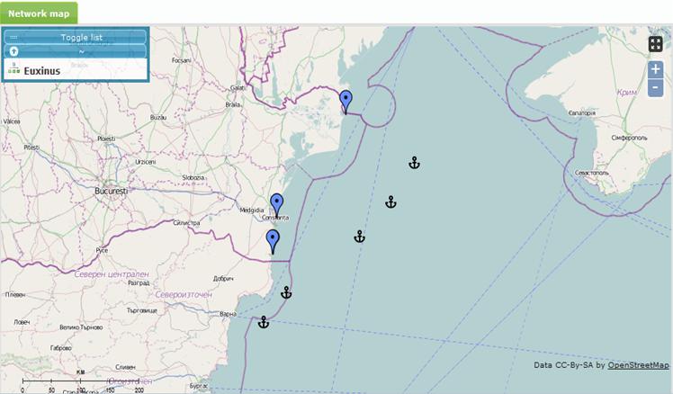 Figure 3. GEM software installed in the framework of the MarineGeohazard project
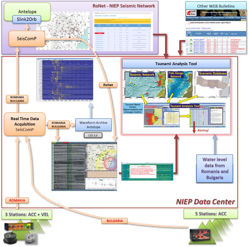 Figure 4a. NIEP Data Centre real-time data flow
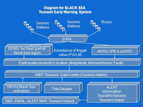 Figure 4b. NIEP Data Centre real-time data flow
The Black Sea area is exposed to tsunamis, as previous studies have shown. The Western part of the Black Sea is mainly affected by the events occurring in the Shabla area. The strongest event generated in the Shabla area occurred in 1901 (Mw 7.2) and generated tsunami waves up to 5 m height.
For the Western part of the Black Sea there are two possible situations:
- Earthquakes occurring close to the Western coast of Black Sea (<=200km epicentral distance). NIEP uses the existing Earthquake Early Warning System (EEWS) together with the Antelope real-time processing and acquisition system to rapidly estimate source parameters.
- Earthquakes with high potential to generate tsunamis occurring at more than 200 km epicentral distance from the coastal area. NIEP uses in this case the Antelope real-time processing and acquisition system to rapidly estimate source parameters. The decision matrix used in both above situations is shown in Figure 5.
| Depth | Location | Mw | Distance to the epicenter | Type of message | Alert level | Technology used |
|---|---|---|---|---|---|---|
| (<100km) | Offshore or inland (=40Km inland) | <5.0 | Everywhere | Information | Green | Antelope |
| 5.0 - 6.0 | Everywhere | Information bulletin | Yellow | Antelope | ||
| 6.0-6.5 | <=200 km | Tsunami Advisory | Orange | EEWS (PRESTo)+Antelope | ||
| >200 km | Information bulletin | Yellow | Antelope | |||
| 6.5-7.0 | <=200 km | Tsunami Watch | Red | EEWS (PRESTo)+Antelope | ||
| >200 km | Tsunami Advisory | Orange | Antelope | |||
| >=7.0 | Everywhere | Tsunami Watch | Red | Antelope | ||
| Inland (>40Km and <100Km inland) | <5.0 | Everywhere | Information | Green | Antelope | |
| 5.0-6.0 | Everywhere | Information bulletin | Yellow | Antelope | ||
| 6.0-6.5 | <=200 km | Information bulletin | Yellow | EEWS (PRESTo)+Antelope | ||
| >200 km | Information bulletin | Yellow | EEWS (PRESTo)+Antelope | |||
| 6.5-7.0 | <=200 km | Tsunami Watch | Red | Antelope | ||
| >200 km | Tsunami Advisory | Orange | ||||
| >=7.0 | Everywhere | Tsunami Watch | Red | Antelope | ||
| (>100km) | Offshore or inland (=100Km) | >=5.0 | Everywhere | Information bulletin | Yellow | Antelope |
Figure 5. Decision matrix derived from Tsunami Analysis Tool (TAT) used at INCDFP RA headquarters.