TSUNAMI HAZARD ASSESSMENT IN BLACK SEA, DUE TO SEISMIC CAUSES
From a total number of 600 earthquakes with moment magnitudes larger than 3.0 only 21 were followed by a small intensity tsunami (NOAA). In Table 2 are presented the Black Sea tsunami events (Papadopoulos et al., 2011). In Figure 1 are plotted the 21 earthquakes from Table 6 that have produced tsunamis.
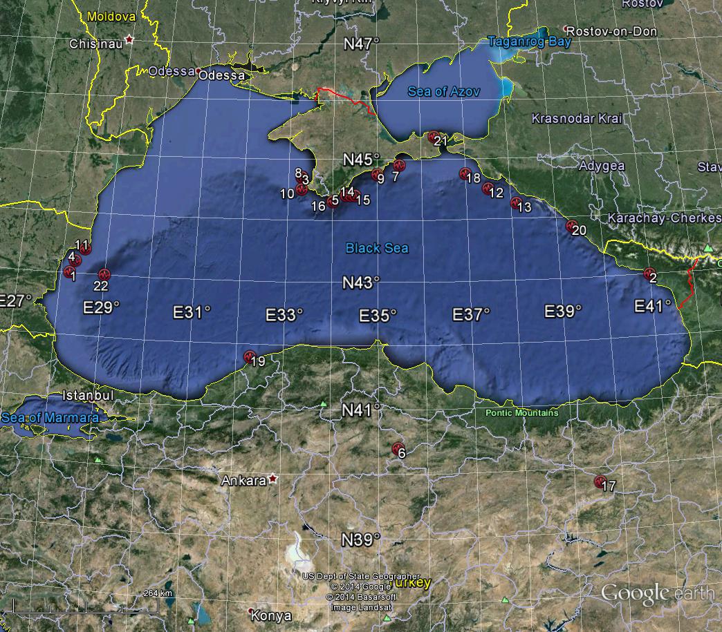 Figure 1. Tsunamis in Black Sea (the numbers on Figure 3 are the number from Tab 2)
From Table 1 we can see that more than 20 tsunamis have so far been observed in the Black Sea. The wave length in the Black Sea was 45-110 m, the velocity of travel was 120-140 km/h and the time of travel from one coast to the other was 10 to 110 minutes (Papadopoulos et al., 2011.).
Table 1. Black Sea tsunami events (Papadopoulos et al., 2011)
|
No. |
Year |
Month |
Day |
HH |
MM |
SS |
Mag |
Lat |
Long |
h |
Zone/ Seismic source |
Wave high (m) |
Tsunami intensity (K) |
Val |
|
1 |
Sec. 1 Î.Hr. |
|
|
|
|
|
|
43.01 |
28.2 |
n |
Bulgaria/S3 |
|
|
3 |
|
2 |
Sec. 1 D.Hr |
|
|
|
|
|
6.5 |
43.00 |
41.00 |
n |
Georgia/S6 |
2.5 |
|
2 |
|
3 |
103 |
|
|
|
|
|
7 |
44.7 |
33.3 |
n |
Ukraine/S8 |
2 |
|
2 |
|
4 |
544 |
|
|
|
|
|
7.5 |
43.2 |
28.3 |
n |
Bulgaria/S3 |
|
VIII-IX |
4 |
|
5 |
1427 |
|
|
|
|
|
7 |
44.4 |
34.3 |
n |
Ukraine/S8 |
>2 |
VII-VIII |
2 |
|
6 |
1598 |
05 |
|
|
|
|
7 |
40.4 |
35.4 |
n |
Turcia/inland |
|
VIII-IX |
3 |
|
7 |
1615 |
06 |
05 |
|
|
|
6.0 |
44.9 |
35.5 |
n |
Ukraine/S8 |
>0.5 |
III-IV |
3 |
|
8 |
1650 |
|
|
|
|
|
7.0 |
44.7 |
33.3 |
n |
Ukraine/S8 |
>0.5 |
4-5 |
3 |
|
9 |
1869 |
11 |
11 |
13 |
|
|
5.8 |
44.75 |
35 |
n |
Ukraine/S8 |
0.5 |
III-IV |
4 |
|
10 |
1875 |
07 |
25 |
|
|
|
5.5 |
44.5 |
33.3 |
n |
Ukraine/S8 |
>0.1 |
III-IV |
3 |
|
11 |
1901 |
03 |
31 |
7 |
12 |
|
7.2 |
43.4 |
28.5 |
n |
Bulgaria/S3 |
2.5 |
III-IV |
3 |
|
12 |
1905 |
10 |
4 |
22 |
29 |
|
5.1 |
44.5 |
37.5 |
n |
Rusia/S7 |
0.5 |
III-IV |
3 |
|
13 |
1909 |
04 |
08 |
|
|
|
|
44.25 |
38.12 |
|
Rusia/S7 |
|
III-IV |
3 |
|
14 |
1927 |
06 |
26 |
11 |
20 |
48 |
6 |
44.4 |
34.4 |
n |
Ukraine/S8 |
0.7 |
III-IV |
4 |
|
15 |
1927 |
09 |
11 |
22 |
15 |
48 |
6.8 |
44.4 |
34.5 |
n |
Ukraine/S8 |
1 |
III-IV |
4 |
|
16 |
1927 |
09 |
16 |
08 |
21 |
|
4.9 |
44.3 |
34 |
n |
Ukraine/S8 |
>0.3 |
III-IV |
4 |
|
17 |
1939 |
12 |
26 |
23 |
57 |
22.6 |
7.9 |
39.77 |
39.533 |
n |
Turcia/inland |
0.53 |
III-IV |
4 |
|
18 |
1966 |
7 |
12 |
18 |
53 |
|
5.8 |
44.75 |
37 |
n |
Rusia/S7 |
0.42 |
III-IV |
4 |
|
19 |
1968 |
9 |
3 |
8 |
19 |
52.2 |
6.6 |
41.8 |
32.3 |
n |
Turcia/S5 |
3 |
IV-V |
4 |
|
20 |
1970 |
12 |
4 |
1 |
59 |
25 |
5.8 |
43.84 |
39.34 |
|
Rusia/S7 |
0.4 |
II-III |
3 |
|
21 |
1990 |
08 |
02 |
|
|
|
|
45.38 |
36.31 |
|
AzS |
0.4 |
III |
3 |
|
22 |
2007 |
5 |
7 |
|
|
|
Landslide |
43 |
29 |
|
Bulgaria/S3 |
1.2 |
IV-V |
4 |
In Table 2 we have used the following notations: VAL = Tsunami Event Validity: Valid values: -1 to 4 Validity of the actual tsunami occurrence is indicated by a numerical rating of the reports of that event:
- 4 = definite tsunami
- 3 = probable tsunami
- 2 = questionable tsunami
- 1 = very doubtful tsunami
- 0 = event that only caused a seiche or disturbance in an inland river
- -1 = erroneous entry
- K = Tsunami Intensity (after Papadopoulos si Imamura, 2001)
Tsunami Simulation using the seismic hazard results Only for Shabla source zone, BS3, we have used the TAT program to obtain some models for tsunami propagation. The simulations are presented in the next pages for different earthquake magnitudes as presented in Table 2. The fault parameters as input for simulations were taken from the existing mechanisms.
Table 2. Expected and most probable magnitudes and their return periods for BS3
|
TR (years) |
Mmp |
Mexp |
|
180 |
7.0 |
7.0 |
|
250 |
7.5 |
7.5 |
|
475 |
8.5 |
8.5 |
In next Figures are presented the maximum waves high on the Black Sea shore, due to a tsunami following an earthquake with Mw=7.0/7.5/8.5, that has a computed return period of 180/250/475 years. In next Figures are also presented the computed sea level for the existing stations locations
2. Tsunami Simulation For An Earthquke With Magnitude Mw= 7.5 (Tr=250 Years), In Shabla Area, Western Black Sea The input earthquake parameters are: Initial conditions: Latitude : 43.45; Longitude: 28.69; Magnitude Mw: 7.5; Depth 10 km Fault Parameters: Strike Angle: 211; Dip: 65; Rake: 171; Width: 14; Length: 50; Displacement: 3.31
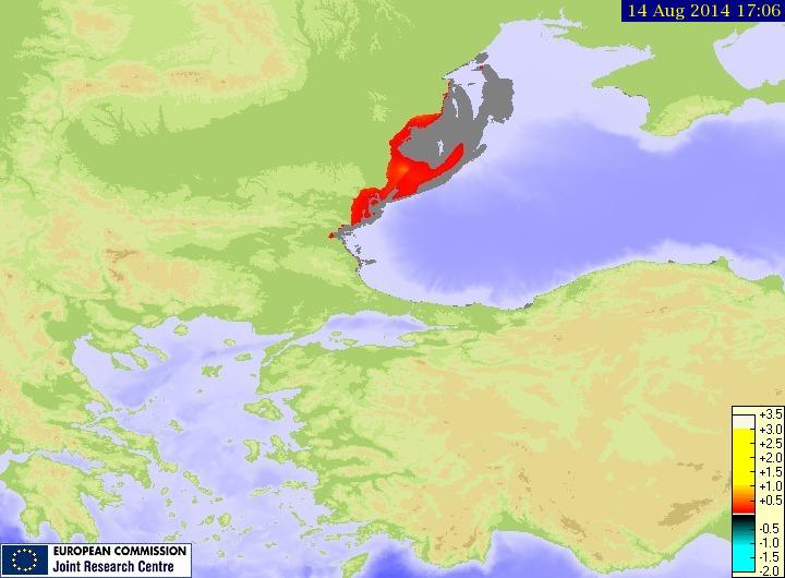 Fig. 4. Maximum wave height
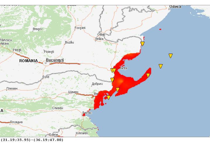 Fig. 5. Maximum wave height, affected locations and sea level stations in the Black Sea
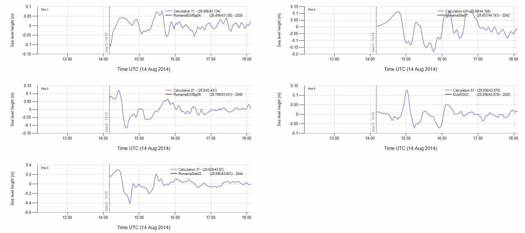 Fig. 6. Computed sea level for stations in the area
Conclusions In the studies above are presented only some examples of tsunami simulation, using only the focal parameters of a medium crustal earthquake occurred in Shabla source zone in 5.08.2009 Mw=5.0. Further studies are required.